Canyon de Chelly National Monument...
Home To Some Of The Most Beautiful Canyons In Northeastern Arizona.
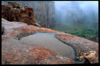
Canyon de Chelly National Monument (NM) has it all: verdant valleys, enclosed by tall sandstone canyon walls, panoramic vistas that stretch from horizon to horizon and mighty rock spires and towers that reach to the heavens.
As if all of this were not enough to hold our attention, tucked away in alcoves high on these walls are Anazasi Ruins, built hundreds of years ago by the Ancient ones.
There are stories to be told in these ruins and in the carved or painted petroglyphs and pictographs adorning the canyon walls. We just have to listen.
Canyon de Chelly (pronounced de shay) is located in northeastern Arizona, about 3 miles (4.8km) east of Chinle, Arizona and 168 miles (271 km) southeast of Page, Arizona.
It is unique in that it is a National Monument, falling under the jurisdiction of the National Park System (NPS), but is located on Navajo Tribal Trust Land and surrounded completely by the Navajo Indian Reservation. As a result Canyon de Chelly National Monument is jointly managed by the NPS and the Navajo Nation.
Canyon de Chelly National Monument encompasses 83,840 acres, or 130 square miles, of some of the most beautiful canyons in northeastern Arizona; all of them with colorful names like: Canyon de Chelly, Canyon del Muerto, Black Rock Canyon, Monument Canyon, Wild Cherry Canyon, Bat Canyon and Twin Trail Canyon.
There is no entry or park fee to visit Canyon de Chelly National Monument which, again, makes it unique.
Much of this vast Monument can be seen on self-guided tours in your own vehicle. However, most of the canyon can only be seen when accompanied by a NPS ranger or a Navajo guide.
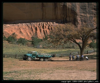
Photograph Courtesy of Philip Greenspun/Philip.greenspun.com
There are group tours, which take visitors into the canyon in large four-wheel drive open trucks, horseback tours, hiking tours and private tours led by local Navajo guides.
I would encourage you to take one of the tours into the canyons. It is the only way to see most of the canyons and most of the ruins up close and personal. The Visitor’s Center has a list of guides and will be glad to help you find one.
A word of caution: book your tour early to insure you have someone lined up for the dates of your visit. This is especially important during the peak tourist season. You don’t want to miss one of these tours because you didn’t call ahead.
For those of you who don’t have the time, are on a limited budget or simply don’t want to be bothered with a guide, there are two rim drives which skirt Canyon de Chelly National Monument: the North Rim Drive and the South Rim Drive. Both of them start from the Visitor’s Center at the Monument and neither of them requires a permit.
The North Rim Drive, along Tribal Route 64, is approximately 30 miles round trip and takes 2 to 3 hours to complete.
There are four designated overlooks along this drive which provides you with wonderful views into Canyon del Muerto (Spanish for canyon of the dead) and some of the cliff dwellings sprinkled throughout the canyon.
The first stop along this drive is at the Ledge Ruin Overlook. Across the canyon you will see the ruins on a ledge about 100 feet above the canyon floor. In order to reach the dwellings, the occupants cut toeholds in the canyon walls. (I guess this is where rock climbing first had its beginning.)
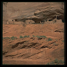
Photograph Courtesy of Philip Greenspun/Philip.Greenspun.com
Just to the south of the Ledge Ruin Overlook is another overlook from where you will be able to see a kiva which was used for religious purposes. It is high on the canyon wall and could only be reached by using the toeholds cut in the canyon wall.
Next stop is the Antelope House Overlook. It is ironic that Antelope House gets its name from pictures of grazing antelope on a nearby cliff, because it is thought that they were drawn, not by the Anasazi, but by a Navajo or Mexican artist in the 1830s.
Before it was abandoned, sometime around A.D. 1276, it was believed to have 91 rooms and a four-story building.
Across the canyon, sits a small alcove about 50 feet above the canyon floor. This is the Tomb of the Weaver, who was found by archaeologists in the 1920s. In the tomb was an old man wrapped in a blanket of what is believed to be golden eagle feathers. Also in the tomb were corn, pinyon nuts, beans, salt and cotton yarn.
A short walk to the east is another overlook from which can be seen a sandstone butte called Navajo Fortress. It was used by the Navajo as a refuge from Spanish and American military assailants.
On the east side of the butte, not seen from the overlook, is a trail leading to the top. Along this trail are make-shift ladders used by the Navajo to climb to the top of the butte. As they climbed, they would remove the ladders, passing them up to the top. From the top, and other strategic places, the Navajo would hurl stones upon their attackers.
Mummy Cave Overlook is the third overlook on this drive and takes its name from the discovery of two mummies found below the ruins. The ruins are located in two deep alcoves several hundred feet above the canyon floor. Many consider this to be one of the most beautiful of the ruins.
In the alcove to your left, towards the east, is the larger of the two, containing 50 rooms and 2 kivas. The alcove to the right, towards the west, contains 20 rooms. The two alcoves are connected by a ledge on which there are 7 rooms and a three-story tower. The tower is similar to those built at Mesa Verde in Colorado and is thought to have been built by immigrants from there.
Massacre Cave Overlook is the last overlook on the North Rim Drive. It was named after the massacre of 115 Navajos in 1805 by Spanish soldiers. This attack was in retaliation to raids by the Navajo on Spanish settlements in the area.
The alcove in which these Navajos took refuge is high above the canyon floor and is not easily accessible. However, the Spanish soldiers were able to climb to the rim overlooking the alcove and fire down upon them. ( Kind of like shooting fish in a barrel and not very sporting.)

Photograph Courtesy of Philip
Greenspun/Philip.greenspun.com
The South Rim Drive starts at the Canyon de Chelly NM Visitor’s Center on Tribal Route 7. The drive is 16 miles one-way and takes from 2 to 3 hours to complete. This takes into consideration the stops at the overlooks along the way.
Tunnel Overlook is the first overlook you will encounter and is 275 feet above the canyon floor. There is not really a tunnel here but rather a narrow canyon. Although there are no ruins to be seen from this overlook, it is quite scenic.
Tsegi Overlook is the second stop along this drive. Tsegi is Navajo for rock canyon. The Spanish pronunciation of Tsegi is “day-shay-yee” but has been corrupted in English to “da Shay.”
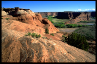
This is a beautiful scenic overlook looking down upon the serpentine Rio de Chelly and lush valley surrounded by spectacular red sandstone canyon walls. This is a photographer’s dream come true.
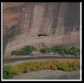
Junction Overlook, so named because it is at the junction of Canyon de Chelly and Canyon del Muerto, is our next stop. As you look out over the verdant valley spread out 400 feet below you will see Canyon del Muerto to the North and Canyon de Chelly to the South.
Although they are difficult to see without binoculars, there are two ruins across the canyon: First Ruins to the left and Junction Ruins to the right. They are both in alcoves high above the canyon floor.
Photograph Courtesy of Philip
Greenspun/Philip.greenspun.com
White House Overlook, which sits about 550 feet above the canyon floor, is the next stop along the drive. It offers a spectacular, if not distant, view of White House Ruin, the lush green valley below and the rust stained canyon walls which rise up on all sides.
To the right, about 500 feet from this overlook, is a trail leading down from the rim to the White House Ruin and is the only trail into the Canyon which may be hiked without a Navajo guide or an NPS ranger to accompany you.
The Navajo call this trail the Women’s Trail because it was used by the Navajo women to move goats and sheep in and out of the canyon.
The dirt trail to the ruins descends about 600 feet in elevation, but is a moderately strenuous hike and is approximately 2.5 miles (4km) round trip.
The trail passes through two short tunnels, each of which can lead to a great photo opportunity.
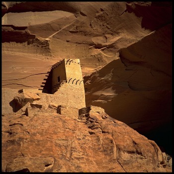
Whitehouse Ruins consist of several two-story structures, on two separate levels; one pretty much above the other. The bottom structures were built at ground level against the canyon wall, whereas the upper structures were built within a large alcove in the canyon wall.
(Maybe this is where the split level home concept originated?) The White House Ruins, along with Spider Rock, is one of the most photographed subjects in the Canyon.
In my photographs of White House Ruin, I like to show the height and enormity of the sheer, desert varnish-stained canyon walls, and how they dwarf the ruins below. For this, I use a 20mm lens on my film camera and a 16mm lens on my digital camera. To get in closer and show more detail in the ruins themselves, I use a lens in the 200mm range.
Speaking of closer, there is a fence restricting visitors from climbing in or around the ruins. Thus, the need for a long lens for “close ups.”
While on the subject of photography, please respect the privacy of the Navajo who call the Canyon home. This is their land and we are the visitors.
Do not photograph them or their dwellings without their permission. You will find that some of them will give you permission but may ask for a fee. Be sure to agree upon a set price before taking pictures. This will prevent any hurt feelings or ruffled feathers.
Keep in mind that this is a 2.5 mile round trip walk, with the second half of it slightly uphill. Wear comfortable shoes and clothing. A hat with a wide brim will help keep the sun out of your eyes and protect your neck from sunburn. Be sure to bring along sunscreen.
And, since it is easy to get dehydrated in this high desert environment, bring plenty of water. For while there are restroom facilities near the Ruins, there is no water.
Sliding House Overlook offers a wonderful panorama of the valley below and the red sandstone canyon walls. Sliding House Ruin is difficult to see from here without the aid of binoculars. It is so named because it rests on a sloping ledge and appears to be about ready to slide down into the valley below. Let’s hope it lasts another thousand years or so.
Wild Cherry Overlook offers a panoramic view of Wild Cherry Canyon. To my knowledge, the Wild Cherry Ruin cannot be seen from this overlook; at least I have not been able to see it.
Face Rock Overlook, located 1000 feet above the canyon floor, is another overlook that offers great views of the valley but nothing spectacular. I say this with reservation, no pun intended, because in the right light and atmospheric conditions, they can all be spectacular.
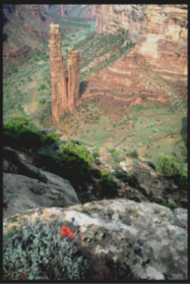
Spider Rock Overlook is the very last overlook on the South Rim Drive, and provides a magnificent view of Spider Rock, the verdant valley from which it rises and the confluence of Canyon de Chelly and Monument Canyon.
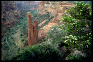
Spider Rock is a stone monolith rising over 800 feet (240 m) from the canyon floor. I’m not sure if it qualifies as a true monolith since it actually splits part way up and becomes two separate spires. Regardless of whether it is a true monolith or not, it is still an impressive rock.
It is, also, a religious symbol for the Navajo and home for Spider Woman, who, among other things, taught the Navajo to weave using a wooden loom made by her husband, Spider Man.
But, Spider Woman has a sinister aspect to her, too, as she is used as a sort of boogey man (or should I say woman) to children. They are told that if they are not good, Spider Woman will come and take them away to her home on top of Spider Rock and eat them.
The top is supposedly littered with their bones and explains why the top of the rock is white.
Camping at the Monument:
Cottonwood Campground is located at Canyon de Chelly National Monument and camping is currently free. However, I understand that the NPS and the Tribe are discussing this. You will want to check with the Park Service before making plans to stay there.
There are 96 sites at the campground with adequate access for big rigs and tent camping is allowed. There are no electric, sewer, TV or water hookups. There are restrooms, and water is available, although I understand water availability can sometimes be a problem.
The one time I stayed at the campground, and this was several years ago, I was kept awake much of the night by barking dogs. The dogs belonged to the nearby Navajo residents and not the other campers.
And, speaking of dogs, there is a regulation at Canyon de Chelly National Monument that all dogs be kept on a lease. Also, they are not allowed in the canyon or on any of the trails, including the self–guided tours. However, as long as they are on a leash, they may be at the overlooks, campgrounds and in the parking lots.
To avoid any confusion about this policy, I suggest you speak with a ranger at the Visitor’s Center.
Spider Rock Campground is located about 9-10 miles south of the Visitor’s Center off Tribal Route 7. This is a privately owned campground with 30 sites. I have driven past the campground but have never visited it. From what I understand, there are no hookups and it is on the primitive side.
In fact, the following was downloaded from the Spider Rock Campground website:
“Spider Rock Campground offers an all-natural camping experience in an unpaved setting amidst the junipers and piñon pines near the rim of Canyon de Chelly in northern Arizona…Prices start at only US$10 for a quiet, shady tent site.”
|
Lodging: Near the bottom of the page, I have listed all of the lodging at the Monument and in Chinle, Arizona along with an overview and contact information. With this information at your fingertips, you can contact them and make your reservations. |
Books and Maps about Canyon de Chelly may be purchased at the Visitor Center, or you may purchase them through Amazon.com by clicking the link below. Canyon de Chelly National Monument |
However, for those of you who would rather not have to bother with this hassle there is much easier way.
Simply use the box below, which is powered by Hotels Combined, to get you the best deals for the dates you have in mind.
This is not a Booking Agency.
Rather it is a search engine designed to help you find available lodging
in Chinle, Arizona on the dates you select and for the best possible
price.
They search through their data base of the 30 biggest booking sites looking for motels with
accommodations available for your selected dates.
The results of this search are then brought back to you with all the information you need to make an informed choice.
To use this service to find lodging at Chinle, simply go to the little box below:
• Under Destination, enter Chinle, Arizona
• Enter the dates you need
• Click "Search"
• ...and you will be taken to a list of Page, Arizona accommodations available for those dates, along with the best price for each one of them. (Page opens in new window.)
Once you have a list of hotels, simply click the ones in which you are interested. For each hotel, you will be given a General Overview plus a number of quality images of the hotel.
Additionally there will be a listing of Hotel Features, such as basic amenities, what additional services are available and check in and check out times.
There will, also, be FAQ’s, and Guest Reviews. All the information you need in which to make an informed choice. Only after you click "Select" on the hotel of choice, will you be sent to a regular booking site. Until then, you remain with the Search Engine.
Finding and selecting lodging has never been easier.
Have A Great Story To Share?
Do you have a great story about this destination? Share it!
Lodging at the Monument:
Thunderbird Lodge, with 73 rustic but modern rooms, a restaurant and gift shop, is the only lodging facility located within Canyon de Chelly National Monument. The single-story adobe building, built in 1930, sits on the site of an historic trading post built in 1896. In fact, the cafeteria-style restaurant is located within the original trading post. Thunderbird Lodge is the only authorized provider of group tours into Canyon de Chelly and Canyon del Muerto. They offer both half-day and full-day tours in large six-wheeled open-air trucks.
Lodging in Chinle:
Holiday Inn Canyon de Chelly is one of two motels in Chinle and was built in 1992. It has 108 rooms located on two separate floors.
It has all the in-room amenities one would expect of a Holiday Inn: air conditioning, satellite television, in room wireless internet access, telephone, mini-refrigerator, coffee maker, hairdryer, iron and ironing board.
In addition to the in-room amenities, it has a seasonal outdoor swimming pool and a restaurant with a casual southwestern flavor. Pets are allowed.
Best Western Canyon de Chelly Inn, the second motel in Chinle, was built in 1966. It has 102 rooms located on two separate floors.
It, too, has all the in-room amenities one would expect from a Best Western Motel: air conditioning, satellite television, telephone with voicemail, and coffee maker.
In addition to the in-room amenities, it has a gift shop which features Native American arts and crafts, a year-round in-door heated pool, hot tub and a restaurant which features Southwest, Native American, Italian and Mexican cuisine. Pets are allowed.
Chinle, Arizona is a small, unincorporated town located in northeastern Arizona, approximately 168 miles (271km) southeast of Page, Arizona and 282 miles (455 km) northeast of Phoenix, Arizona. It is surrounded on all four sides by the Navajo Indian Reservation.
Chinle’s chief claim to fame (no pun intended) is that it is the gateway to Canyon de Chelly National Monument which is just 3 miles to the east.
The only other attraction in Chinle, of which I am aware, is the Ned A. Hatathali Museum which is located on the Navajo Community College, northeast of town. (You will also see this referred to as Dine College).
The museum houses approximately 3,000 Native American artifacts, including paintings, photographs, pottery, documents and textiles.
Chinle, AZ Current Weather and Forecast
Time Change:
Arizona, unlike most of the United States, does not observe Daylight Savings Time (DST). However, because part of the Navajo Tribal Land is located in the states of Colorado, New Mexico and Utah, which do observe DST, the Navajo Nation DOES observes DST.
Therefore, from March through November, all time on the reservation is one hour ahead of the rest of Arizona.
Climate at the Canyon:
Spring: Usually, cool and windy. Expect high temperatures to be anywhere between 50 and 70 degrees Fahrenheit and lows in the 30s.
Summer: Hot and dry. Expect high temperatures to range from 85 to 100 degrees Fahrenheit and lows in the 50s.
Fall: Generally pleasant, with highs between 60 and 80 degrees Fahrenheit and lows in the 40s.
Winter: Can be cold and windy. High temperatures are usually between 40 and 60 degrees Fahrenheit with lows in the high teens.
Contact Information:
Canyon de Chelly National Monument PO Box 588 Chinle, AZ 86503 TN: 928-674-5500
Best Western Canyon de Chelly Inn PO Box 295 Chinle, AZ 86503 TN: 928-674-5875 or 800-327-0354 www.canyondechelly.com
Holiday Inn Canyon de Chelly PO Box 1889 Chinle, AZ 86503 TN: 928-674-5000 or 800-HOLIDAY www.holiday-inn.com
Thunderbird Lodge PO Box 548 Chinle, AZ 86503 TN: 928-674-5841 or 800-679-2473 www.tbirdlodge.com
Spider Rock Campground PO Box 2509 Chinle, AZ 86503 TN: 928-674-8261 info@spiderrockcampground.com
Fun Facts:
• The name of Canyon de Chelly was derived from the misspelling and mispronunciation of the Navajo word for the canyon. The Navajos call the canyon "Tseyi" which is pronounced 'say-ee.' Eventually the word became "de Chelly" which is pronounced as 'de-shay' or ‘da-shay’.
• Chinle is a Census-Designated Place, which means that it is a populated area that lacks a separate municipal government and is not officially incorporated by the state in which it is located.
Return From Canyon de Chelly National Monument to Home Page

